Back
Satellite Imagery Annotation Outsourcing Philippines: Mapping Global Intelligence from Orbit

By Ralf Ellspermann / 22 March 2026
 Authored by Ralf Ellspermann, CSO of PITON-Global, & 25-Year Philippine BPO Veteran | Executive | Verified by John Maczynski, CEO of PITON-Global, and Former Global EVP of the World's Largest BPO Provider on March 22, 2026

TL;DR: The Key Takeaway
Satellite imagery annotation outsourcing has transcended simple object detection, evolving into a highly specialized field where expert human cognition is the key to unlocking global intelligence from orbital data. The Philippines has emerged as the premier destination for this work, offering a unique fusion of technical skill and analytical judgment that powers the world’s most advanced geospatial AI.
High-fidelity geospatial labeling in the Philippines transforms raw orbital data into decisive intelligence for defense, climate science, and urban planning. By integrating expert human cognition with machine learning, Filipino specialists provide the precise semantic segmentation and change detection necessary for training autonomous systems and securing global supply chains in 2026.
- Strategic Shift: Industry focus has migrated from high-volume labeling to high-impact intelligence that drives disaster response and national security.
- Expert Ecosystem: The Philippines offers a sophisticated blend of analytical talent and secure infrastructure tailored for sensitive geospatial datasets.
- Cognitive Partnership: Local specialists serve as “AI Pilots,” providing the nuanced object classification that algorithms cannot achieve alone.
- Data Sovereignty: Robust security protocols ensure that mission-critical imagery remains protected throughout the annotation lifecycle.
- PITON-Global’s Role: Acting as a strategic bridge, the firm connects global enterprises with elite Philippine teams to ensure ground-truth accuracy.
From Pixels to Policy: The Strategic Importance of Geospatial AI
The vantage point from orbit has reached unprecedented clarity, yet the sheer scale of data produced daily is staggering. A vast array of orbital sensors now harvests petabytes of high-resolution imagery, capturing the Earth’s surface in minute detail. While this data holds the power to reshape industries and monitor planetary health, raw pixels remain inert without context. True value is birthed through meticulous annotation, which equips artificial intelligence with the “sight” required to recognize patterns and forecast shifts.
Human intuition remains the linchpin of this technological evolution. While a machine might identify a generic structure, a professional annotator discerns the functional difference between a logistics hub and a medical facility. These experts detect the faint signatures of early-stage deforestation or the subtle architectural changes indicative of urban expansion. Such granular interpretation forms the backbone of modern geospatial intelligence, enabling defense agencies to track assets and agricultural firms to stabilize food security. The efficacy of global policy often rests on the precision of these underlying labels.
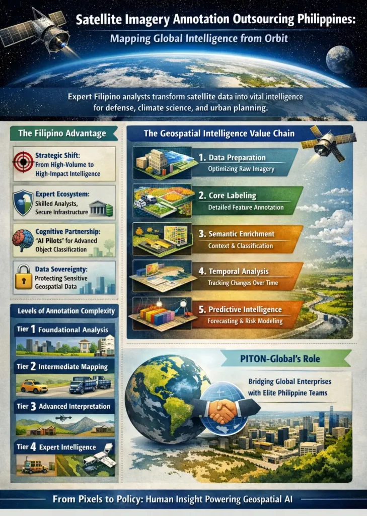
The Geospatial Intelligence Value Chain: From Data to Decision
Converting satellite captures into strategic foresight involves a sophisticated, multi-tiered pipeline. This progression requires a symbiotic relationship between cutting-edge software and specialized human oversight. The Philippines has cultivated a world-class environment for every phase of this refinement process.
| Stage | Description | Key Activities | Role of Philippine Expertise |
| 1. Data Preparation | Raw sensor data is ingested and optimized for human and machine review. | Georeferencing, orthorectification, and format standardization. | Maintaining data fidelity and readiness for downstream analysis. |
| 2. Core Labeling | Fundamental identification of features using digital geometry. | Polygons, bounding boxes, and keypoint marking. | Delivering high-accuracy, scalable labeling for massive datasets. |
| 3. Semantic Enrichment | Layers of specialized context are integrated into the basic visual data. | Land use classification and detailed feature attribution. | Applying localized and domain-specific knowledge to add depth. |
| 4. Temporal Analysis | Comparative studies of chronological imagery to identify evolution. | Monitoring urban sprawl and assessing post-disaster wreckage. | Executing rigorous, detail-oriented audits of environmental change. |
| 5. Predictive Intelligence | Annotated “ground truth” is used to calibrate forecasting models. | Crop yield estimation and infrastructure risk modeling. | Providing the high-quality training data that powers AI accuracy. |
This hierarchy proves that satellite imagery annotation outsourcing Philippines is far more than a technical utility; it is a spectrum of cognitive services. The local outsourcing sector has matured significantly, transitioning from simple marking to complex intelligence synthesis.
Intelligence Arbitrage in Orbit: The Philippine Advantage
In the competitive landscape of 2026, “Intelligence Arbitrage” defines the quest for informational dominance. This concept transcends labor costs, focusing instead on the strategic superiority gained through better data. By utilizing the analytical strengths of Filipino professionals, organizations gain a clearer picture of the world than their rivals, facilitating faster and more accurate maneuvers.
“Our partners in the geospatial arena are locked in a race for information supremacy. They do not seek mere data entry; they require a strategic edge. They need collaborators who possess the mindset of an intelligence analyst—individuals capable of spotting anomalies that escape standard algorithms. Our objective is to bridge the gap between global firms and the elite Filipino specialists who transform satellite feeds into undeniable predictive power.” — John Maczynski, CEO, PITON-Global
Several pillars support this cognitive advantage. The local workforce combines high educational attainment with a natural facility for visual logic and critical thinking. When paired with stringent data privacy laws and a culture aligned with international business standards, the result is a secure harbor for sensitive geospatial intelligence. This synergy elevates outsourcing from a cost-saving measure to a primary driver of global insight.
Geospatial Annotation Complexity Matrix
Not all pixels are created equal. The difficulty of annotation tasks varies based on the required domain expertise and the stakes of the final output. To optimize resources, PITON-Global employs a tiered complexity model to match project requirements with the appropriate talent level.
Tier 1: Foundational Analysis
Tasks include broad land cover mapping and basic building detection. This level requires extreme attention to detail and tool proficiency to create essential baseline maps.
Tier 2: Intermediate Mapping
This involves distinguishing vehicle types or mapping intricate road networks. It demands high visual acuity and the ability to navigate multi-layered rule sets for transportation and asset management.
Tier 3: Advanced Interpretation
Focusing on semantic segmentation of chaotic scenes or tracking moving targets across frames. Specialists here often hold backgrounds in engineering or environmental science to assist in disaster recovery and precision farming.
Tier 4: Expert Intelligence
The highest level involves anomaly detection for national security or validating AI predictions through “Agentic Governance.” This tier requires deep critical thinking and the ability to infer human intent from orbital patterns.
The Future of Geospatial Intelligence: A Human-Machine Symbiosis
Looking toward the horizon of late 2026, the sector is moving toward a profound partnership between silicon and soul. As automated tools handle repetitive marking, the human role is being elevated, not erased. Tomorrow’s specialists are “AI Pilots,” focused on high-level validation, ethical oversight, and the governance of automated systems.
The Philippines is uniquely prepared to anchor this future. Significant investments in technical education and a mature infrastructure for high-stakes BPO services make the archipelago the ideal cockpit for human-in-the-loop AI. By offering the critical judgment that code lacks, Filipino analysts remain the essential force translating orbital data into the intelligence that defines our understanding of the planet.
Expert FAQs
Which annotation techniques are currently seeing the highest demand?
There is a massive surge in requests for 3D point cloud annotation (LiDAR) for autonomous navigation and high-resolution semantic segmentation for climate change monitoring. Defense sectors are also increasingly seeking expert-level change detection for critical infrastructure.
How is sensitive satellite data protected during the outsourcing process?
Top-tier providers in the Philippines utilize ISO 27001-certified facilities featuring biometric access, encrypted data tunnels, and strictly monitored networks. These physical and digital barriers, supported by the country’s Data Privacy Act, ensure high-level security for sovereign or proprietary data.
What exactly is “Agentic Governance” in geospatial AI?
This refers to the human-led verification of autonomous AI outputs. In high-stakes environments—like identifying military assets or detecting illegal mining—human experts act as a “firewall,” reviewing AI findings to ensure logical consistency and prevent “hallucinations” before the data reaches decision-makers.
Does the geographic time difference impact project efficiency?
The “follow-the-sun” model provides a significant speed advantage. While Western teams finish their day, Philippine teams begin processing the data. This allows for a 24-hour production cycle, often delivering annotated results back to the client by the following morning.
Achieve sustainable growth with world-class BPO solutions!
PITON-Global connects you with industry-leading outsourcing providers to enhance customer experience, lower costs, and drive business success.
Get Your Top 1% Vendor List
Author
Ralf Ellspermann is a multi-awarded outsourcing executive with 25+ years of call center and BPO leadership in the Philippines, helping 500+ high-growth and mid-market companies scale call center and customer experience operations across financial services, fintech, insurance, healthcare, technology, travel, utilities, and social media.
A globally recognized industry authority - and a contributor to The Times of India, CustomerThink, and The AI Journal - he advises organizations on building compliant, high-performance offshore contact center operations that deliver measurable cost savings and sustained competitive advantage.
Known for his execution-first approach, Ralf bridges strategy and operations to turn call center and business process outsourcing into a true growth engine. His work consistently drives faster market entry, lower risk, and long-term operational resilience for global brands.
EXECUTIVE GOVERNANCE & ACCURACY STANDARDS
Authored by:

Ralf Ellspermann
Founder & CSO of PITON-Global,
25-Year Philippine BPO Veteran,
Multi-awarded Executive
Specializing in strategic sourcing and excellence in Manila
View Full Bio
Verified by:

John Maczynski
CEO of PITON-Global, and former Global EVP of the World’s largest BPO provider | 40 Years Experience
Ensuring global compliance and enterprise-grade service standards
View Full Bio
Last Peer Review: March 22, 2026
This service framework is audited quarterly to meet shifting global outsourcing regulations and COPC standards.